
La Barrière topographic map
Interactive map
Click on the map to display elevation.
About this map
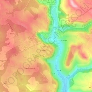
Name: La Barrière topographic map, elevation, terrain.
Average elevation: 951 ft
Minimum elevation: 568 ft
Maximum elevation: 1,224 ft
Other topographic maps
Click on a map to view its topography, its elevation and its terrain.
Genebrières
France > Occitanie > Tarn-et-Garonne > Caylus
Genebrières, Caylus, Montauban, Tarn-et-Garonne, Occitanie, France métropolitaine, 82160, France
Average elevation: 1,106 ft