
Make a donation
Gear up for your next adventure:
As an Amazon Associate, this site earns from qualifying purchases at no extra cost to you.
Villa La Angostura topographic map
Click on the map to display elevation.
Make a donation
Gear up for your next adventure:
As an Amazon Associate, this site earns from qualifying purchases at no extra cost to you.
Villa La Angostura
The elevation of the city centre is about 790 m (2,590 ft), and the lake is at 765 m (2,510 ft). Surrounding mountains range from 1,500 m (4,900 ft) to about 2,000 m (6,600 ft) (Cerro Bayo, right behind the city, is 1,782 m (5,846 ft) high).
Make a donation
Gear up for your next adventure:
As an Amazon Associate, this site earns from qualifying purchases at no extra cost to you.
About this map
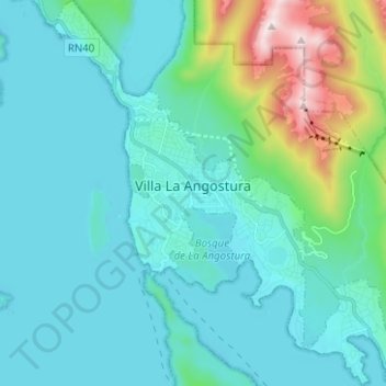
Name: Villa La Angostura topographic map, elevation, terrain.
Average elevation: 3,022 ft
Minimum elevation: 2,477 ft
Maximum elevation: 5,984 ft
Make a donation
Gear up for your next adventure:
As an Amazon Associate, this site earns from qualifying purchases at no extra cost to you.
Other topographic maps
Click on a map to view its topography, its elevation and its terrain.
Make a donation
Gear up for your next adventure:
As an Amazon Associate, this site earns from qualifying purchases at no extra cost to you.
Piedra del Águila
Argentina > Neuquén Province > Municipio de Piedra del Águila
Average elevation: 1,768 ft