
La Estrimera topographic map
Interactive map
Click on the map to display elevation.
About this map
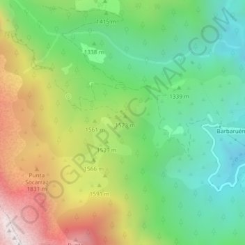
Name: La Estrimera topographic map, elevation, terrain.
Location: La Estrimera, Seira, Ribagorce, Huesca, Aragon, Espagne (42.49314 0.37000 42.51314 0.39000)
Average elevation: 4,767 ft
Minimum elevation: 3,199 ft
Maximum elevation: 7,297 ft
Other topographic maps
Click on a map to view its topography, its elevation and its terrain.
Simas de Armeña
Espagne > Aragon > Ribagorce > Seira
Simas de Armeña, Seira, Ribagorce, Huesca, Aragon, Espagne
Average elevation: 7,621 ft