
Mendro topographic map
Interactive map
Click on the map to display elevation.
About this map
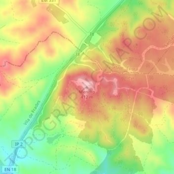
Name: Mendro topographic map, elevation, terrain.
Location: Mendro, Vidigueira, Beja, 7220-494, Portugal (38.24617 -7.78391 38.24627 -7.78381)
Average elevation: 1,083 ft
Minimum elevation: 761 ft
Maximum elevation: 1,345 ft
Other topographic maps
Click on a map to view its topography, its elevation and its terrain.
Serra do Mendro
Portugal > Beja > Vidigueira
Serra do Mendro, Vidigueira, Beja, 7220-494, Portugal
Average elevation: 1,138 ft
Selmes
Portugal > Beja > Vidigueira
Selmes, Vidigueira, Beja, 7960-167, Portugal
Average elevation: 486 ft