
Elmwood Park Historic District topographic map
Interactive map
Click on the map to display elevation.
About this map
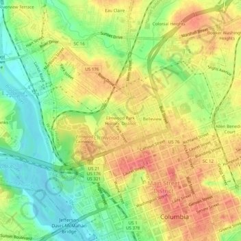
Name: Elmwood Park Historic District topographic map, elevation, terrain.
Average elevation: 249 ft
Minimum elevation: 125 ft
Maximum elevation: 361 ft
Other topographic maps
Click on a map to view its topography, its elevation and its terrain.
Forest Hills
United States > South Carolina > Richland County > Columbia
Forest Hills, Columbia, Richland County, South Carolina, 29204, United States
Average elevation: 282 ft
Riverbanks
United States > South Carolina > Richland County > Columbia
Riverbanks, Columbia, Richland County, South Carolina, 29202, United States
Average elevation: 226 ft
Strathaven Forest
United States > South Carolina > Richland County > Columbia
Strathaven Forest, Columbia, Richland County, South Carolina, 29209, United States
Average elevation: 269 ft
Fairfield Arms
United States > South Carolina > Richland County > Columbia
Fairfield Arms, Columbia, Richland County, South Carolina, 29203, United States
Average elevation: 285 ft
Harbison State Forest
United States > South Carolina > Richland County > Columbia
Harbison State Forest, Columbia, Richland County, South Carolina, United States
Average elevation: 259 ft