
Trupe topographic map
Interactive map
Click on the map to display elevation.
About this map
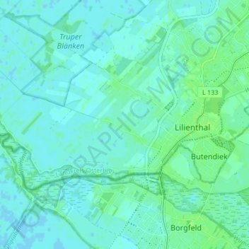
Name: Trupe topographic map, elevation, terrain.
Average elevation: 10 ft
Minimum elevation: -3 ft
Maximum elevation: 26 ft
Other topographic maps
Click on a map to view its topography, its elevation and its terrain.
Seebergen
Deutschland > Niedersachsen > Landkreis Osterholz > Lilienthal
Seebergen, Lilienthal, Landkreis Osterholz, Niedersachsen, Deutschland
Average elevation: 16 ft
Frankenburg
Deutschland > Niedersachsen > Landkreis Osterholz > Lilienthal
Frankenburg, Lilienthal, Landkreis Osterholz, Niedersachsen, 28865, Deutschland
Average elevation: 13 ft
Worphausen
Deutschland > Niedersachsen > Landkreis Osterholz > Lilienthal
Worphausen, Lilienthal, Landkreis Osterholz, Niedersachsen, 28865, Deutschland
Average elevation: 20 ft