
Hinter Fiescherhorn topographic map
Interactive map
Click on the map to display elevation.
About this map
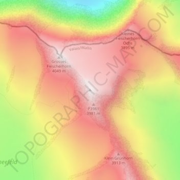
Name: Hinter Fiescherhorn topographic map, elevation, terrain.
Location: Hinter Fiescherhorn, Fieschertal, Goms, Vallese, Svizzera (46.54642 8.06751 46.54652 8.06761)
Average elevation: 11,519 ft
Minimum elevation: 9,022 ft
Maximum elevation: 13,130 ft
Other topographic maps
Click on a map to view its topography, its elevation and its terrain.
Trugberg
Svizzera > Vallese > Fieschertal
Trugberg, Fieschertal, Goms, Vallese, Svizzera
Average elevation: 11,342 ft
Fiescher Gabelhorn
Svizzera > Vallese > Fieschertal
Fiescher Gabelhorn, Fieschertal, Goms, Vallese, Svizzera
Average elevation: 10,823 ft
Jungfraujoch
Svizzera > Vallese > Fieschertal
Jungfraujoch, Fieschertal, Goms, Vallese, 3801, Svizzera
Average elevation: 10,850 ft
Finsteraarhorn
Svizzera > Vallese > Fieschertal
Finsteraarhorn, Fieschertal, Goms, Vallese, Svizzera
Average elevation: 11,220 ft
Ebnefluh/Äbeni Flue
Svizzera > Vallese > Fieschertal
Ebnefluh/Äbeni Flue, Fieschertal, Goms, Vallese, Svizzera
Average elevation: 11,253 ft
Dreieckhorn
Svizzera > Vallese > Fieschertal
Dreieckhorn, Fieschertal, Goms, Vallese, Svizzera
Average elevation: 10,528 ft
Grosses Fiescherhorn
Svizzera > Vallese > Fieschertal
Grosses Fiescherhorn, Fieschertal, Goms, Vallese, Svizzera
Average elevation: 11,178 ft