
Banyalbufar topographic map
Interactive map
Click on the map to display elevation.
About this map
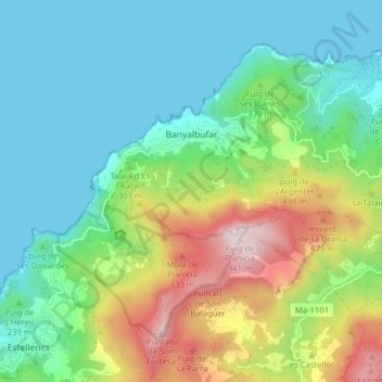
Name: Banyalbufar topographic map, elevation, terrain.
Location: Banyalbufar, Serra de Tramuntana, Isole Baleari, 07191, Spagna (39.65484 2.48725 39.70180 2.56618)
Average elevation: 886 ft
Minimum elevation: -3 ft
Maximum elevation: 3,045 ft
Other topographic maps
Click on a map to view its topography, its elevation and its terrain.
Escorca
Spagna > Isole Baleari > Serra de Tramuntana
Escorca, Serra de Tramuntana, Isole Baleari, 07315, Spagna
Average elevation: 1,253 ft