
Gaishorn topographic map
Interactive map
Click on the map to display elevation.
About this map
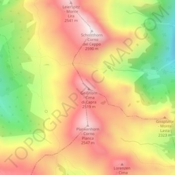
Name: Gaishorn topographic map, elevation, terrain.
Location: Gaishorn, Vahrn, Eisacktal, Bozen, Trentino-Südtirol, Italien (46.72407 11.51107 46.72417 11.51117)
Average elevation: 7,320 ft
Minimum elevation: 5,899 ft
Maximum elevation: 8,432 ft
Other topographic maps
Click on a map to view its topography, its elevation and its terrain.
Vahrn
Italien > Trentino-Südtirol > Vahrn > Vahrn
Vahrn, Eisacktal, Bozen, Trentino-Südtirol, Italien
Average elevation: 4,124 ft