
Make a donation
Gear up for your next adventure:
As an Amazon Associate, this site earns from qualifying purchases at no extra cost to you.
Paine topographic map
Click on the map to display elevation.
Make a donation
Gear up for your next adventure:
As an Amazon Associate, this site earns from qualifying purchases at no extra cost to you.
Paine
The Aculeo Lagoon was located within the commune of Paine, it was one of the main recreation centers for the people of Santiago and the only natural lagoon in the region. There are various campsites in the sector. In its territory are also the Altos de Cantillana, a natural reserve consisting of high-altitude mountains, whose plants and animals are worthy of interest. In addition, this commune is a place of huasas traditions.
Make a donation
Gear up for your next adventure:
As an Amazon Associate, this site earns from qualifying purchases at no extra cost to you.
About this map
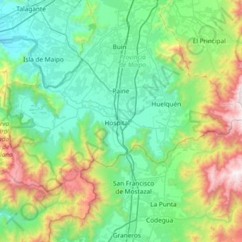
Name: Paine topographic map, elevation, terrain.
Average elevation: 2,674 ft
Minimum elevation: 866 ft
Maximum elevation: 8,957 ft
Make a donation
Gear up for your next adventure:
As an Amazon Associate, this site earns from qualifying purchases at no extra cost to you.
Other topographic maps
Click on a map to view its topography, its elevation and its terrain.
El Barrancón Norte
Chile > Santiago Metropolitan Region > Provincia de Maipo
Average elevation: 1,873 ft