
Sudheim topographic map
Interactive map
Click on the map to display elevation.
About this map
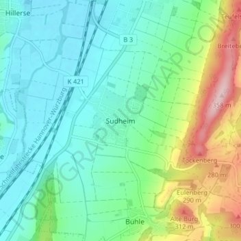
Name: Sudheim topographic map, elevation, terrain.
Average elevation: 577 ft
Minimum elevation: 377 ft
Maximum elevation: 1,135 ft
Other topographic maps
Click on a map to view its topography, its elevation and its terrain.
Hillerse
Deutschland > Niedersachsen > Landkreis Northeim > Northeim
Hillerse, Northeim, Landkreis Northeim, Niedersachsen, 37154, Deutschland
Average elevation: 466 ft
Steinkuhle
Deutschland > Niedersachsen > Landkreis Northeim > Northeim
Steinkuhle, Northeim, Landkreis Northeim, Niedersachsen, Deutschland
Average elevation: 456 ft