
Baaiduinen topographic map
Interactive map
Click on the map to display elevation.
About this map
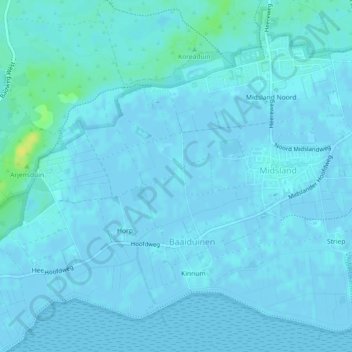
Name: Baaiduinen topographic map, elevation, terrain.
Location: Baaiduinen, Terschelling, Friesland, Niederlande (53.37568 5.26322 53.38906 5.28367)
Average elevation: 7 ft
Minimum elevation: -10 ft
Maximum elevation: 62 ft
Other topographic maps
Click on a map to view its topography, its elevation and its terrain.
Terschelling
Niederlande > Friesland > Terschelling
Terschelling, Friesland, Niederlande
Average elevation: 0 ft
Formerum
Niederlande > Friesland > Terschelling
Formerum, Terschelling, Friesland, Niederlande
Average elevation: 0 ft
Hoorn
Niederlande > Friesland > Terschelling
Hoorn, Terschelling, Friesland, Niederlande
Average elevation: 7 ft