
Steckborn topographic map
Interactive map
Click on the map to display elevation.
About this map
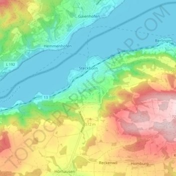
Name: Steckborn topographic map, elevation, terrain.
Location: Steckborn, Bezirk Frauenfeld, Thurgovie, 8266, Suisse (47.64639 8.94767 47.67134 9.03222)
Average elevation: 1,677 ft
Minimum elevation: 1,283 ft
Maximum elevation: 2,356 ft
Other topographic maps
Click on a map to view its topography, its elevation and its terrain.
Gerlikon
Suisse > Thurgovie > Bezirk Frauenfeld > Frauenfeld
Gerlikon, Frauenfeld, Neunforn, Bezirk Frauenfeld, Thurgovie, 8500, Suisse
Average elevation: 1,624 ft
Frauenfeld
Suisse > Thurgovie > Bezirk Frauenfeld
Frauenfeld, Bezirk Frauenfeld, Thurgovie, Suisse
Average elevation: 1,506 ft