
Bezirksteil Haidhausen Süd topographic map
Interactive map
Click on the map to display elevation.
About this map
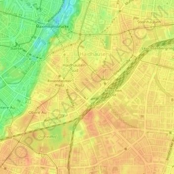
Name: Bezirksteil Haidhausen Süd topographic map, elevation, terrain.
Average elevation: 1,745 ft
Minimum elevation: 1,657 ft
Maximum elevation: 1,785 ft
Other topographic maps
Click on a map to view its topography, its elevation and its terrain.
Thalkirchen-Obersendling-Forstenried-Fürstenried-Solln
Deutschland > Bayern > München > Warnberg
Thalkirchen-Obersendling-Forstenried-Fürstenried-Solln, Warnberg, München, Bayern, 82049, Deutschland
Average elevation: 1,880 ft
Bezirksteil Hackenviertel
Deutschland > Bayern > München
Bezirksteil Hackenviertel, Stadtbezirk 01 Altstadt-Lehel, München, Oberbayern, Bayern, 80331, Deutschland
Average elevation: 1,719 ft