
Er Espà topographic map
Interactive map
Click on the map to display elevation.
About this map
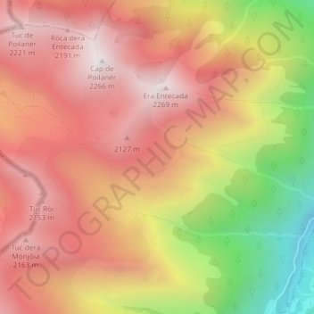
Name: Er Espà topographic map, elevation, terrain.
Location: Er Espà, es Bòrdes, Val-d'Aran, Lérida, Catalogne, Espagne (42.70206 0.68597 42.72206 0.70597)
Average elevation: 5,968 ft
Minimum elevation: 3,615 ft
Maximum elevation: 7,434 ft
Other topographic maps
Click on a map to view its topography, its elevation and its terrain.
Benòs
Espagne > Catalogne > Val-d'Aran > es Bòrdes
Benòs, es Bòrdes, Val-d'Aran, Lérida, Catalogne, 25551, Espagne
Average elevation: 4,026 ft