
Papandayan topographic map
Interactive map
Click on the map to display elevation.
About this map
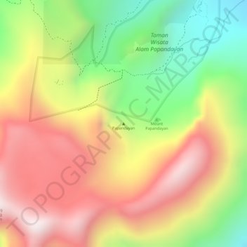
Name: Papandayan topographic map, elevation, terrain.
Location: Papandayan, Bandung, West-Java, Indonesien (-7.32005 107.72995 -7.31995 107.73005)
Average elevation: 7,608 ft
Minimum elevation: 6,358 ft
Maximum elevation: 8,655 ft
Other topographic maps
Click on a map to view its topography, its elevation and its terrain.
Gunung Kendang
Indonesien > West-Java > Bandung
Gunung Kendang, Bandung, West-Java, Indonesien
Average elevation: 7,493 ft
Wayang-Windu
Indonesien > West-Java > Bandung
Wayang-Windu, Bandung, West-Java, Indonesien
Average elevation: 5,889 ft
Kamojang, Kawah
Indonesien > West-Java > Bandung
Kamojang, Kawah, Bandung, West-Java, Indonesien
Average elevation: 5,213 ft