
Bersted topographic map
Interactive map
Click on the map to display elevation.
About this map
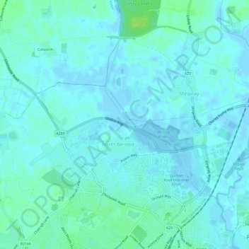
Name: Bersted topographic map, elevation, terrain.
Average elevation: 10 ft
Minimum elevation: -10 ft
Maximum elevation: 43 ft
Other topographic maps
Click on a map to view its topography, its elevation and its terrain.
Littlehampton
United Kingdom > England > Arun > Littlehampton
Littlehampton, Arun, West Sussex, South East England, England, BN17 5EJ, United Kingdom
Average elevation: 13 ft
Ferring
United Kingdom > England > Arun > Ferring
Ferring, Arun, West Sussex, South East, England, BN12 5NE, United Kingdom
Average elevation: 20 ft
Westergate
United Kingdom > England > Arun > Westergate
Westergate, Arun, West Sussex, South East, England, United Kingdom
Average elevation: 30 ft