
Stann Creek District topographic map
Interactive map
Click on the map to display elevation.
About this map
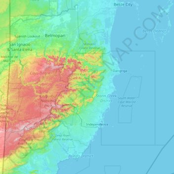
Name: Stann Creek District topographic map, elevation, terrain.
Location: Stann Creek District, Belize (16.13333 -89.20000 17.53333 -87.80000)
Average elevation: 482 ft
Minimum elevation: -7 ft
Maximum elevation: 3,599 ft
Other topographic maps
Click on a map to view its topography, its elevation and its terrain.
Red Bank
Red Bank, Stann Creek District, Belize
Average elevation: 262 ft
Columbus Caye
Columbus Caye, Stann Creek District, Belize
Average elevation: 0 ft
Hopkins
Belize > Stann Creek District > Hopkins
Hopkins, Stann Creek District, Belize
Average elevation: 7 ft