
Innertkirchen topographic map
Interactive map
Click on the map to display elevation.
About this map
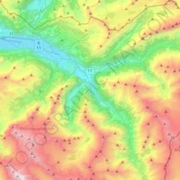
Name: Innertkirchen topographic map, elevation, terrain.
Average elevation: 6,381 ft
Minimum elevation: 1,870 ft
Maximum elevation: 13,199 ft
Other topographic maps
Click on a map to view its topography, its elevation and its terrain.
Titlis
Suisse > Berne > Arrondissement administratif d'Interlaken-Oberhasli > Innertkirchen
Titlis, Innertkirchen, Arrondissement administratif d'Interlaken-Oberhasli, Région administrative de l'Oberland, Berne, 3862, Suisse
Average elevation: 8,268 ft