
Saddle Peak topographic map
Interactive map
Click on the map to display elevation.
About this map
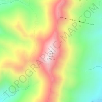
Name: Saddle Peak topographic map, elevation, terrain.
Location: Saddle Peak, Gallatin County, Montana, VS (45.79349 -110.93666 45.79359 -110.93656)
Average elevation: 7,720 ft
Minimum elevation: 6,496 ft
Maximum elevation: 9,137 ft
Other topographic maps
Click on a map to view its topography, its elevation and its terrain.
Elkhorn Hot Springs
VS > Montana > Elkhorn Hot Springs
Elkhorn Hot Springs, Beaverhead County, Montana, 59646, VS
Average elevation: 7,421 ft
Glacier National Park
Glacier National Park, Sperry Lake, Flathead County, Montana, VS
Average elevation: 5,230 ft