
Stedtfeld topographic map
Interactive map
Click on the map to display elevation.
About this map
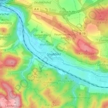
Name: Stedtfeld topographic map, elevation, terrain.
Average elevation: 909 ft
Minimum elevation: 643 ft
Maximum elevation: 1,302 ft
Other topographic maps
Click on a map to view its topography, its elevation and its terrain.
Hötzelsroda
Deutschland > Thüringen > Wartburgkreis > Eisenach
Hötzelsroda, Eisenach, Wutha-Farnroda, Wartburgkreis, Thüringen, 99817, Deutschland
Average elevation: 968 ft
Steinkopf
Deutschland > Thüringen > Wartburgkreis > Eisenach
Steinkopf, Eisenach, Wartburgkreis, Thüringen, 99848, Deutschland
Average elevation: 1,010 ft
Hirschkopf
Deutschland > Thüringen > Wartburgkreis > Eisenach
Hirschkopf, Eisenach, Wutha-Farnroda, Wartburgkreis, Thüringen, 99848, Deutschland
Average elevation: 915 ft
Hörschel
Deutschland > Thüringen > Wartburgkreis > Eisenach > Hörschel
Hörschel, Eisenach, Wartburgkreis, Thüringen, 99819, Deutschland
Average elevation: 837 ft