
Selby topographic map
Interactive map
Click on the map to display elevation.
About this map
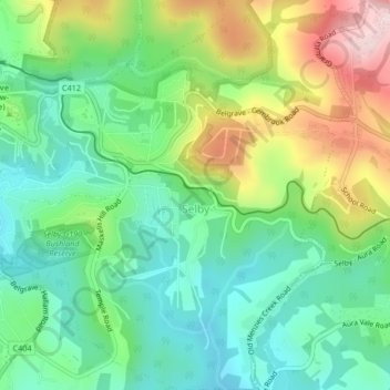
Name: Selby topographic map, elevation, terrain.
Average elevation: 820 ft
Minimum elevation: 472 ft
Maximum elevation: 1,480 ft
Other topographic maps
Click on a map to view its topography, its elevation and its terrain.
Monbulk Creek Retarding Basin (Melb Water)
Australia > Victoria > Belgrave
Monbulk Creek Retarding Basin (Melb Water), Lysterfield, Belgrave, Shire of Yarra Ranges, Victoria, 3160, Australia
Average elevation: 551 ft