
Katerini Municipality topographic map
Click on the map to display elevation.
Katerini Municipality
Katerini (Greek: Κατερίνη, romanized: Kateríni, pronounced [kateˈrini]) is a city and a municipality in northern Greece. It is the capital of the Pieria regional unit in Central Macedonia. It lies on the Pierian plain, between Mount Olympus and the Thermaikos Gulf, at an altitude of 14 m. The municipality of Katerini has a population of 82,892 (according to the 2021 census). It is the second most populous urban area in the Greek region of Macedonia after Thessaloniki. The close distance between the two cities (68 km), has been beneficial for Katerini's development over recent years. Katerini is accessible from the A1/E75 Athens–Thessaloniki motorway (with the Katerini's South, East and North interchanges) and the A2 motorway to the north. It is served by Intercity, Proastiakos (suburban train) and local trains on the main Athens-Thessaloniki railway line and there is a comprehensive regional and national bus service with its hub in the city.
About this map
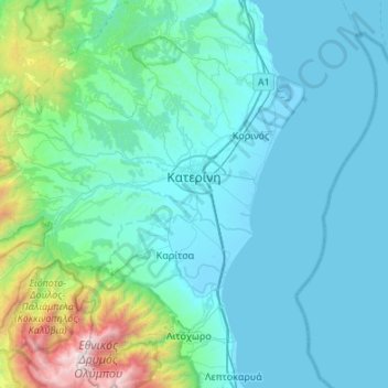
Name: Katerini Municipality topographic map, elevation, terrain.
Average elevation: 1,093 ft
Minimum elevation: -13 ft
Maximum elevation: 9,478 ft
Other topographic maps
Click on a map to view its topography, its elevation and its terrain.
Αβδέλλα
Greece > Central Macedonia > Pieria Regional Unit > Katerini Municipality
Average elevation: 6,115 ft
Τόξο
Greece > Central Macedonia > Pieria Regional Unit > Katerini Municipality
Average elevation: 774 ft
Λιτόχωρο
Greece > Central Macedonia > Pieria Regional Unit
At an altitude of 850 m, beside the Enipeas gorge, Saint Dionysios built a monastery. Founded 1542, its name was Agia Triada, what means Holy Trinity, later changed to the name of the Saint. Plundered and burned several times in its history, it received the final blow from German troops in April 1943.
Average elevation: 1,299 ft