
Make a donation
Gear up for your next adventure:
As an Amazon Associate, this site earns from qualifying purchases at no extra cost to you.
Wałbrzych topographic map
Click on the map to display elevation.
Make a donation
Gear up for your next adventure:
As an Amazon Associate, this site earns from qualifying purchases at no extra cost to you.
Wałbrzych
Wałbrzych is located in the Central Sudeten Mountains, near the border with the Czech Republic and Germany. The city is located by the Pełcznica River at 450–500 m above sea level in a picturesque structural basin of Wałbrzych above which there are wooded ranges of the Wałbrzych Mountains. The highest elevation in the city is Mount Borowa, also known as the Black Mountain, 853 m (2798 ft) above sea level, with an observation tower since 2007, which is the highest peak of the Wałbrzych mountains.
Make a donation
Gear up for your next adventure:
As an Amazon Associate, this site earns from qualifying purchases at no extra cost to you.
About this map
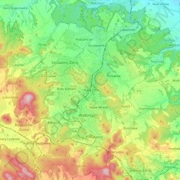
Name: Wałbrzych topographic map, elevation, terrain.
Location: Wałbrzych, Lower Silesian Voivodeship, Poland (50.71609 16.22718 50.85414 16.35527)
Average elevation: 1,568 ft
Minimum elevation: 902 ft
Maximum elevation: 2,785 ft
Make a donation
Gear up for your next adventure:
As an Amazon Associate, this site earns from qualifying purchases at no extra cost to you.
Other topographic maps
Click on a map to view its topography, its elevation and its terrain.
Góry Kaczawskie
Poland > Lower Silesian Voivodeship > Złotoryja County > Wojcieszów
Average elevation: 1,726 ft
Węglówka
Poland > Lower Silesian Voivodeship > Ząbkowice Śląskie County > Opolnica
Average elevation: 1,283 ft
Make a donation
Gear up for your next adventure:
As an Amazon Associate, this site earns from qualifying purchases at no extra cost to you.
Kopciowa
Poland > Lower Silesian Voivodeship > Ząbkowice Śląskie County > Chwalisław
Average elevation: 1,939 ft
Wojcieszyce Dolne
Poland > Lower Silesian Voivodeship > Karkonosze County > Wojcieszyce
Average elevation: 1,335 ft
Make a donation
Gear up for your next adventure:
As an Amazon Associate, this site earns from qualifying purchases at no extra cost to you.
Sokolik Duży
Poland > Lower Silesian Voivodeship > Karkonosze County > Bobrów
Average elevation: 1,414 ft
Śnieżka / Sněžka
Poland > Lower Silesian Voivodeship > Karkonosze County > Karpacz
Due to high altitude the climate is maritime polar (Köppen: ET) not far from a continental subpolar climate (Dfc). The difference should be at least 6 °C lower on annual average compared to the weather station in the plains.
Average elevation: 4,144 ft
Kowadło/Kovadlina
Poland > Lower Silesian Voivodeship > Kłodzko County > Bielice
Average elevation: 2,602 ft
Góry Sowie
Poland > Lower Silesian Voivodeship > Wałbrzych County > Rzeczka
Seen from the Silesian Lowlands in the northeast, the Owl Mountains form a comparatively steep edge of the Central Sudetes, though the range is very diversified in terms of height. The highest peaks are Wielka Sowa ("Great Owl", at 1,014 m (3,327 ft) in altitude) and Kalenica (964 m (3,163 ft)) with their…
Average elevation: 2,726 ft
Make a donation
Gear up for your next adventure:
As an Amazon Associate, this site earns from qualifying purchases at no extra cost to you.
Szubianka
Poland > Lower Silesian Voivodeship > Kamienna Góra County > Kamienna Góra
Average elevation: 1,535 ft
Śnieżka / Sněžka
Poland > Lower Silesian Voivodeship > Karkonosze County > Karpacz
Due to high altitude the climate is maritime polar (Köppen: ET) not far from a continental subpolar climate (Dfc). The difference should be at least 6 °C lower on annual average compared to the weather station in the plains.
Average elevation: 4,144 ft
Szklary-Huta
Poland > Lower Silesian Voivodeship > Ząbkowice Śląskie County
Average elevation: 1,007 ft
Make a donation
Gear up for your next adventure:
As an Amazon Associate, this site earns from qualifying purchases at no extra cost to you.
Zamek Grodziec
Poland > Lower Silesian Voivodeship > Złotoryja County > Grodziec
Average elevation: 883 ft
Jelenia
Poland > Lower Silesian Voivodeship > Bolesławiec County > Bronowiec
Average elevation: 512 ft
Make a donation
Gear up for your next adventure:
As an Amazon Associate, this site earns from qualifying purchases at no extra cost to you.
Sienna
Poland > Lower Silesian Voivodeship > Trzebnica County > Rościsławice
Average elevation: 528 ft
Karkonosze
Poland > Lower Silesian Voivodeship > Jelenia Góra
The Giant Mountains, Krkonoše, or Karkonosze (Czech: [ˈkr̩konoʃɛ] , Polish pronunciation: [karkɔˈnɔʂɛ] , German: Riesengebirge pronounced [ˈʁiːzn̩ɡəˌbɪʁɡə] ), are a mountain range located in the north of the Czech Republic and the south-west of Poland, part of the Sudetes mountain system…
Average elevation: 3,924 ft
Make a donation
Gear up for your next adventure:
As an Amazon Associate, this site earns from qualifying purchases at no extra cost to you.
Bystrzyca Kłodzka
Poland > Lower Silesian Voivodeship > Kłodzko County > Bystrzyca Kłodzka > Bystrzyca Kłodzka
Average elevation: 1,325 ft
Pop
Poland > Lower Silesian Voivodeship > Zgorzelec County > Studniska Dolne
Average elevation: 712 ft
Czernica
Poland > Lower Silesian Voivodeship > Dzierżoniów County > Jaźwina
Average elevation: 1,184 ft