
Ciudad Valles topographic map
Interactive map
Click on the map to display elevation.
About this map
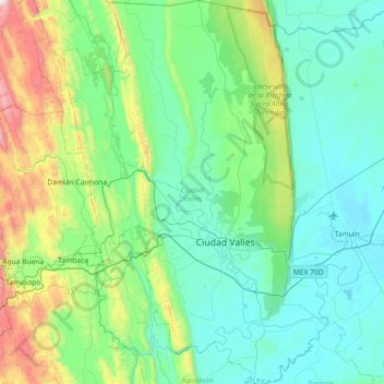
Name: Ciudad Valles topographic map, elevation, terrain.
Location: Ciudad Valles, San Luis Potosí, México (21.74170 -99.33730 22.41529 -98.81728)
Average elevation: 1,017 ft
Minimum elevation: 49 ft
Maximum elevation: 5,505 ft
Other topographic maps
Click on a map to view its topography, its elevation and its terrain.
Soledad de Graciano Sánchez
Soledad de Graciano Sánchez, San Luis Potosí, México
Average elevation: 6,234 ft
Ciudad Valles
México > San Luis Potosí > Ciudad Valles
Ciudad Valles, San Luis Potosí, 79000, México
Average elevation: 594 ft