
Make a donation
Gear up for your next adventure:
As an Amazon Associate, this site earns from qualifying purchases at no extra cost to you.
Corfu topographic map
Click on the map to display elevation.
Make a donation
Gear up for your next adventure:
As an Amazon Associate, this site earns from qualifying purchases at no extra cost to you.
Corfu
Two high and well-defined ranges divide the island into three districts, of which the northern is mountainous, the central undulating, and the southern low-lying. The more important of the two ranges, that of Pantokrator (Παντοκράτωρ – the Almighty) stretches east and west from Cape Falacro to Cape Psaromita, and attains its greatest elevation in the summit of the same name.
Make a donation
Gear up for your next adventure:
As an Amazon Associate, this site earns from qualifying purchases at no extra cost to you.
About this map
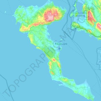
Name: Corfu topographic map, elevation, terrain.
Average elevation: 135 ft
Minimum elevation: -23 ft
Maximum elevation: 2,913 ft
Make a donation
Gear up for your next adventure:
As an Amazon Associate, this site earns from qualifying purchases at no extra cost to you.
Other topographic maps
Click on a map to view its topography, its elevation and its terrain.
Roda
Greece > Peloponnese, Western Greece and the Ionian > Corfu Regional Unit
Average elevation: 82 ft
Kassiopi
Greece > Peloponnese, Western Greece and the Ionian > Corfu Regional Unit > Kassopaia Municipal Unit
Average elevation: 194 ft
Sidari
Greece > Peloponnese, Western Greece and the Ionian > Corfu Regional Unit
Average elevation: 43 ft
Plakoto
Greece > Peloponnese, Western Greece and the Ionian > Corfu Regional Unit > Glyfada
Average elevation: 223 ft
Make a donation
Gear up for your next adventure:
As an Amazon Associate, this site earns from qualifying purchases at no extra cost to you.
Kontogialos
Greece > Peloponnese, Western Greece and the Ionian > Corfu Regional Unit > Pelekas
Average elevation: 213 ft
Glyfa
Greece > Peloponnese, Western Greece and the Ionian > Corfu Regional Unit > Barbati
Average elevation: 745 ft
Kynopiastes
Greece > Peloponnese, Western Greece and the Ionian > Corfu Regional Unit
Average elevation: 384 ft
Nymphes
Greece > Peloponnese, Western Greece and the Ionian > Corfu Regional Unit
Average elevation: 499 ft
Make a donation
Gear up for your next adventure:
As an Amazon Associate, this site earns from qualifying purchases at no extra cost to you.
Lefkimmi
Greece > Peloponnese, Western Greece and the Ionian > Corfu Regional Unit > Municipal Unit of Lefkimmi
Average elevation: 56 ft
Moraitika
Greece > Peloponnese, Western Greece and the Ionian > Corfu Regional Unit > Municipal Unit of Meliteieis
Average elevation: 79 ft
Afionas
Greece > Peloponnese, Western Greece and the Ionian > Corfu Regional Unit
Average elevation: 85 ft
Palaiokastritsa
Greece > Peloponnese, Western Greece and the Ionian > Corfu Regional Unit
Average elevation: 505 ft
Make a donation
Gear up for your next adventure:
As an Amazon Associate, this site earns from qualifying purchases at no extra cost to you.
Gouvia
Greece > Peloponnese, Western Greece and the Ionian > Corfu Regional Unit
Average elevation: 95 ft