
Make a donation
Gear up for your next adventure:
As an Amazon Associate, this site earns from qualifying purchases at no extra cost to you.
San Jose topographic map
Click on the map to display elevation.
Make a donation
Gear up for your next adventure:
As an Amazon Associate, this site earns from qualifying purchases at no extra cost to you.
About this map
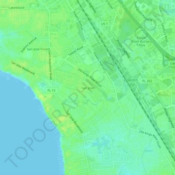
Name: San Jose topographic map, elevation, terrain.
Average elevation: 23 ft
Minimum elevation: 0 ft
Maximum elevation: 46 ft
Duval County trails, hiking, mountain biking, running and outdoor activities
Make a donation
Gear up for your next adventure:
As an Amazon Associate, this site earns from qualifying purchases at no extra cost to you.
Other topographic maps
Click on a map to view its topography, its elevation and its terrain.
Pumpkin Hill Creek Preserve State Park
United States > Florida > Duval County > Jacksonville
Average elevation: 13 ft
Isle of Palms Park
United States > Florida > Duval County > Jacksonville > Isle of Palms
Average elevation: 10 ft
Make a donation
Gear up for your next adventure:
As an Amazon Associate, this site earns from qualifying purchases at no extra cost to you.
Williamson Creek
United States > Florida > Duval County > Jacksonville > Cedar Hills Estates
Average elevation: 36 ft
Make a donation
Gear up for your next adventure:
As an Amazon Associate, this site earns from qualifying purchases at no extra cost to you.
Ryder Park
United States > Florida > Duval County > Jacksonville > Grand Park
Average elevation: 33 ft