
Galicia topographic map
Interactive map
Click on the map to display elevation.
About this map
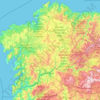
Name: Galicia topographic map, elevation, terrain.
Location: Galicia, España (41.80737 -9.30154 43.79042 -6.73395)
Average elevation: 1,496 ft
Minimum elevation: -7 ft
Maximum elevation: 6,850 ft
Other topographic maps
Click on a map to view its topography, its elevation and its terrain.
Villalba
España > Galicia > Tierra Chá
Villalba, Tierra Chá, Lugo, Galicia, España
Average elevation: 1,670 ft
Camariñas
España > Galicia > Tierra de Soneira
Camariñas, Tierra de Soneira, La Coruña, Galicia, 15123, España
Average elevation: 108 ft
Monte de Guilán
Monte de Guilán, Xove, Mariña Occidental, Lugo, Galicia, 27863, España
Average elevation: 814 ft