
Longeas topographic map
Interactive map
Click on the map to display elevation.
About this map
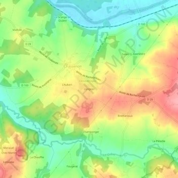
Name: Longeas topographic map, elevation, terrain.
Average elevation: 659 ft
Minimum elevation: 495 ft
Maximum elevation: 856 ft
Other topographic maps
Click on a map to view its topography, its elevation and its terrain.
Cassinomagus
Frankreich > Neu-Aquitanien > Charente > Chassenon > Longeas
Cassinomagus, Route de Champonger, Longeas, Chassenon, Confolens, Charente, Neu-Aquitanien, Metropolitanes Frankreich, 16150, Frankreich
Average elevation: 673 ft