
Saint-Charles-de-Mandeville topographic map
Interactive map
Click on the map to display elevation.
About this map
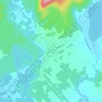
Name: Saint-Charles-de-Mandeville topographic map, elevation, terrain.
Average elevation: 548 ft
Minimum elevation: 469 ft
Maximum elevation: 981 ft
Other topographic maps
Click on a map to view its topography, its elevation and its terrain.
Lac Long
Canada > Québec > D'Autray > Mandeville
Lac Long, Mandeville, D'Autray, Lanaudière, Québec, Canada
Average elevation: 823 ft
Lac McGrey
Canada > Québec > D'Autray > Mandeville
Lac McGrey, Mandeville, D'Autray, Lanaudière, Québec, Canada
Average elevation: 1,135 ft
Lac des Chevreaux
Canada > Québec > D'Autray > Mandeville
Lac des Chevreaux, Mandeville, D'Autray, Lanaudière, Québec, Canada
Average elevation: 1,516 ft
Lac aux Bouleaux
Canada > Québec > D'Autray > Mandeville
Lac aux Bouleaux, Mandeville, D'Autray, Lanaudière, Québec, Canada
Average elevation: 1,237 ft
Lac Mandeville
Canada > Québec > D'Autray > Mandeville
Lac Mandeville, Mandeville, D'Autray, Lanaudière, Québec, Canada
Average elevation: 568 ft
Lac Edward
Canada > Québec > D'Autray > Mandeville
Lac Edward, Mandeville, D'Autray, Lanaudière, Québec, Canada
Average elevation: 1,227 ft
Rivière Mandeville
Canada > Québec > D'Autray > Mandeville > Saint-Charles-de-Mandeville
Rivière Mandeville, Saint-Charles-de-Mandeville, Mandeville, D'Autray, Lanaudière, Québec, Canada
Average elevation: 751 ft