
Gargellen topographic map
Interactive map
Click on the map to display elevation.
About this map
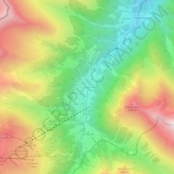
Name: Gargellen topographic map, elevation, terrain.
Average elevation: 5,902 ft
Minimum elevation: 4,072 ft
Maximum elevation: 8,238 ft
Other topographic maps
Click on a map to view its topography, its elevation and its terrain.
Galgenul
Oostenrijk > Vorarlberg > Bezirk Bludenz > Gemeinde Sankt Gallenkirch
Galgenul, Gemeinde Sankt Gallenkirch, Bezirk Bludenz, Vorarlberg, 6791, Oostenrijk
Average elevation: 3,917 ft
Vergalda
Oostenrijk > Vorarlberg > Bezirk Bludenz > Gemeinde Sankt Gallenkirch > Gargellen
Vergalda, Gargellen, Gemeinde Sankt Gallenkirch, Bezirk Bludenz, Vorarlberg, 6791, Oostenrijk
Average elevation: 6,207 ft