
Créhen topographic map
Interactive map
Click on the map to display elevation.
About this map
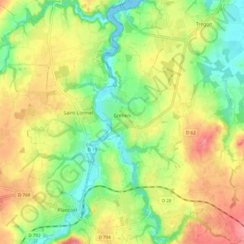
Name: Créhen topographic map, elevation, terrain.
Average elevation: 121 ft
Minimum elevation: 0 ft
Maximum elevation: 259 ft
Other topographic maps
Click on a map to view its topography, its elevation and its terrain.
Le Guildo
France > Brittany > Côtes-d'Armor > Créhen
Le Guildo, Créhen, Dinan, Côtes-d'Armor, Brittany, Metropolitan France, 22130, France
Average elevation: 105 ft