
Alamogordo topographic map
Interactive map
Click on the map to display elevation.
About this map
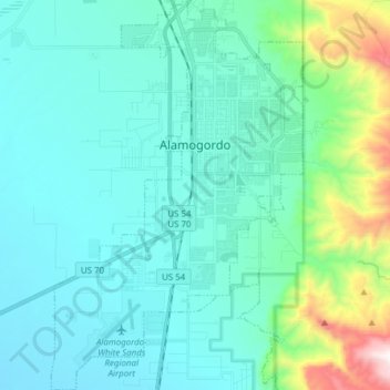
Name: Alamogordo topographic map, elevation, terrain.
Location: Alamogordo, Otero County, New Mexico, United States (32.81874 -106.01686 32.94756 -105.91772)
Average elevation: 4,970 ft
Minimum elevation: 4,094 ft
Maximum elevation: 8,094 ft
As of 2010, Alamogordo had a total area of 19.3 square miles (50.0 km2), all of it land. The city is located at an elevation of 4,336 feet (1,322 m) on the western flank of the Sacramento Mountains and on the eastern edge of the Tularosa Basin. It lies within the Rio Grande rift and in the northernmost part of the Chihuahuan Desert.:36 Tectonic activity is low in the Tularosa Basin. Plants native to the area are typical of the southern New Mexico foothills and include creosote bush, mesquite, saltbush, cottonwood, desert willow, and many species of cactus and yucca.
Other topographic maps
Click on a map to view its topography, its elevation and its terrain.
Cloudcroft
United States > New Mexico > Otero County
Cloudcroft, Otero County, New Mexico, United States
Average elevation: 8,671 ft
Alamorosa
United States > New Mexico > Otero County
Alamorosa, Otero County, New Mexico, 88337, United States
Average elevation: 4,478 ft
La Luz
United States > New Mexico > Otero County
La Luz, Otero County, New Mexico, 88337, United States
Average elevation: 4,764 ft
Orogrande
United States > New Mexico > Otero County
Orogrande, Otero County, New Mexico, 88342, United States
Average elevation: 4,216 ft
Weed
United States > New Mexico > Otero County
Weed, Otero County, New Mexico, 88354, United States
Average elevation: 7,257 ft
Timberon
United States > New Mexico > Otero County
Timberon, Otero County, New Mexico, 88350, United States
Average elevation: 7,156 ft
Apache
United States > New Mexico > Otero County
Apache, Otero County, New Mexico, United States
Average elevation: 6,421 ft
Cloudcroft
United States > New Mexico > Otero County > Cloudcroft
Cloudcroft, Otero County, New Mexico, 88317, United States
Average elevation: 8,648 ft
White Sands National Park
United States > New Mexico > Otero County
White Sands National Park, Otero County, New Mexico, United States
Average elevation: 3,983 ft
Alamogordo
United States > New Mexico > Otero County
Alamogordo, Otero County, New Mexico, 88310, United States
Average elevation: 5,394 ft
La Luz
United States > New Mexico > Otero County
La Luz, Otero County, New Mexico, 88337, United States
Average elevation: 4,898 ft
High Rolls
United States > New Mexico > Otero County
High Rolls, Otero County, New Mexico, 88325, United States
Average elevation: 6,680 ft
Mayhill
United States > New Mexico > Otero County
Mayhill, Otero County, New Mexico, United States
Average elevation: 6,903 ft
Sacramento
United States > New Mexico > Otero County
Sacramento, Otero County, New Mexico, 88347, United States
Average elevation: 7,612 ft