
Cloudcroft topographic map
Click on the map to display elevation.
Cloudcroft
Cloudcroft is a village in Otero County, New Mexico, United States, and is located within the Lincoln National Forest. The population was 674 at the 2010 census. Despite being located in an otherwise arid region, its high elevation (8,676 feet (2,644 m); one of the highest in the U.S.) allows for a mild summer that makes it a popular tourist attraction in west Texas and southern New Mexico. It was named by Fodor's in 2002 as the Number 3 "Most Overlooked and Underrated Destination Spot." Tourism remains the primary economic driver of the village.
About this map
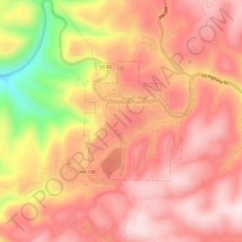
Name: Cloudcroft topographic map, elevation, terrain.
Location: Cloudcroft, Otero County, New Mexico, United States (32.94456 -105.75004 32.96421 -105.70277)
Average elevation: 8,671 ft
Minimum elevation: 7,717 ft
Maximum elevation: 9,108 ft
Otero County trails, hiking, mountain biking, running and outdoor activities
Other topographic maps
Click on a map to view its topography, its elevation and its terrain.
Sunspot
United States > New Mexico > Otero County
Sunspot is an unincorporated community in the Sacramento Mountains in the Lincoln National Forest in Otero County, New Mexico, United States, about 18 miles (29 km) south of Cloudcroft. Its elevation is 9,186 feet (2,800 m). The Sunspot Solar Observatory and Apache Point Observatory are located in Sunspot in…
Average elevation: 8,615 ft
High Rolls
United States > New Mexico > Otero County
The first official use of the High Rolls name was in 1901, when the post office was moved from Fresnal (Wooten) to High Rolls. The name, which was sometimes spelled as one word, Highrolls, supposedly came from the shape and elevation of the area as compared to the sharper peaks higher up.
Average elevation: 6,680 ft
Chihuahuan Desert
United States > New Mexico > Otero County
There are several larger mountain ranges in the Chihuahan Desert, including the Sierra Madre, the Sierra del Carmen, the Organ Mountains, the Franklin Mountains, the Sacramento Mountains, the Chisos Mountains, the Guadalupe Mountains, and the Davis Mountains. These create "sky islands" of cooler, wetter,…
Average elevation: 4,006 ft
High Rolls
United States > New Mexico > Otero County
The first official use of the High Rolls name was in 1901, when the post office was moved from Fresnal (Wooten) to High Rolls. The name, which was sometimes spelled as one word, Highrolls, supposedly came from the shape and elevation of the area as compared to the sharper peaks higher up.
Average elevation: 6,680 ft
Sunspot
United States > New Mexico > Otero County
The origins of Sunspot as a Solar Observatory date back to the sudden increased interest of solar physics to the US military during the Second World War. In 1940, the High Altitude Observatory (HAO) was established in 1940 in Climax, Colorado, by Walter Orr Roberts and Donald Menzel. It was associated with…
Average elevation: 8,615 ft