
Leutkirch im Allgäu topographic map
Interactive map
Click on the map to display elevation.
About this map
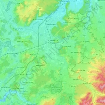
Name: Leutkirch im Allgäu topographic map, elevation, terrain.
Average elevation: 2,290 ft
Minimum elevation: 1,998 ft
Maximum elevation: 3,215 ft
Other topographic maps
Click on a map to view its topography, its elevation and its terrain.
Urlau
Germany > Baden-Württemberg > Landkreis Ravensburg > Leutkirch im Allgäu > Urlau
Urlau, Leutkirch im Allgäu, Verwaltungsgemeinschaft Leutkirch im Allgäu, Landkreis Ravensburg, Baden-Württemberg, 88299, Germany
Average elevation: 2,290 ft