
Visapur topographic map
Interactive map
Click on the map to display elevation.
About this map
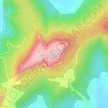
Name: Visapur topographic map, elevation, terrain.
Location: Visapur, Pune, Maharashtra, 411001, India (18.72171 73.49271 18.72181 73.49281)
Average elevation: 2,697 ft
Minimum elevation: 2,005 ft
Maximum elevation: 3,530 ft
Other topographic maps
Click on a map to view its topography, its elevation and its terrain.
Shaniwarwada
India > Maharashtra > Pune
Shaniwarwada, Shivaji Road, Kasba Peth, Pune, Pune District, Maharashtra, 411002, India
Average elevation: 1,837 ft
Koregaon Park
India > Maharashtra > Pune
Koregaon Park, Suyojan Society, Ghorpuri, Pune, Maharashtra, 411001, India
Average elevation: 1,821 ft
Ambil Odha
India > Maharashtra > Pune
Ambil Odha, Pune, Pune City, Pune, Maharashtra, 411001, India
Average elevation: 1,932 ft
Vetal Tekdi
India > Maharashtra > Pune
Vetal Tekdi, Pune, Maharashtra, 411053, India
Average elevation: 2,041 ft