
Zamarramala topographic map
Interactive map
Click on the map to display elevation.
About this map
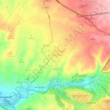
Name: Zamarramala topographic map, elevation, terrain.
Location: Zamarramala, Segovia, Castilla y León, 40003, España (40.94541 -4.15458 40.98541 -4.11458)
Average elevation: 3,264 ft
Minimum elevation: 2,946 ft
Maximum elevation: 3,533 ft
Other topographic maps
Click on a map to view its topography, its elevation and its terrain.
Segovia
España > Castilla y León > Segovia
Segovia, Castilla y León, 40001, España
Average elevation: 3,763 ft
Peñas Labradas
España > Castilla y León > Segovia
Peñas Labradas, Segovia, Castilla y León, 40005, España
Average elevation: 3,235 ft