
Jos topographic map
Click on the map to display elevation.
Jos
At an altitude of 1,217 m (3,993 ft) above sea level, Jos' climate is closer to temperate than that of the vast majority of Nigeria. Average monthly temperatures range from 21–25 °C (70–77 °F), and from mid-November to late January, night-time temperatures drop as low as 7 °C (45 °F). Hail sometimes falls during the rainy season because of the cooler temperatures at high altitudes. These cooler temperatures have, from colonial times until the present day, made Jos a favourite holiday location for both tourists and expatriates based in Nigeria.
About this map
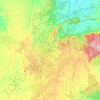
Name: Jos topographic map, elevation, terrain.
Location: Jos, Jos North, Plateau State, 903105, Nigeria (9.75751 8.73794 10.07751 9.05794)
Average elevation: 3,875 ft
Minimum elevation: 2,779 ft
Maximum elevation: 5,768 ft