
Lac Cayuga topographic map
Interactive map
Click on the map to display elevation.
About this map
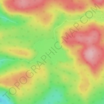
Name: Lac Cayuga topographic map, elevation, terrain.
Average elevation: 1,096 ft
Minimum elevation: 797 ft
Maximum elevation: 1,335 ft
Other topographic maps
Click on a map to view its topography, its elevation and its terrain.
Lac Érié
Canada > Québec > Lac-Pythonga
Lac Érié, Lac-Pythonga, La Vallée-de-la-Gatineau, Outaouais, Québec, Canada
Average elevation: 1,411 ft
Lac Vanda
Canada > Québec > Lac-Pythonga
Lac Vanda, Route 117, Lac-Pythonga, La Vallée-de-la-Gatineau, Outaouais, Québec, Canada
Average elevation: 1,273 ft