
Pedregal topographic map
Interactive map
Click on the map to display elevation.
About this map
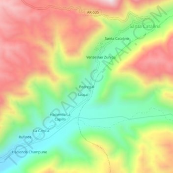
Name: Pedregal topographic map, elevation, terrain.
Location: Pedregal, Río Grande, Condesuyos, Arequipa, Perú (-15.90143 -73.03527 -15.86143 -72.99527)
Average elevation: 3,724 ft
Minimum elevation: 2,523 ft
Maximum elevation: 5,108 ft
Other topographic maps
Click on a map to view its topography, its elevation and its terrain.
Plaza Rosario
Perú > Arequipa > Río Grande > Iquipí
Plaza Rosario, Iquipí, Río Grande, Condesuyos, Arequipa, Perú
Average elevation: 2,326 ft
Río Grande
Perú > Arequipa > Río Grande
Río Grande, Provincia de Condesuyos, Arequipa, Perú
Average elevation: 5,823 ft
Piuca
Perú > Arequipa > Río Grande > Piuca
Piuca, Río Grande, Provincia de Condesuyos, Arequipa, Perú
Average elevation: 2,369 ft