
Slate Island topographic map
Interactive map
Click on the map to display elevation.
About this map
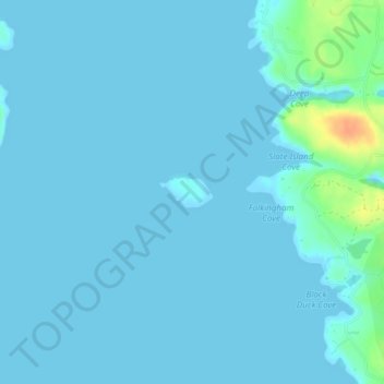
Name: Slate Island topographic map, elevation, terrain.
Location: Slate Island, Beals, Washington County, Maine, United States (44.48571 -67.61516 44.48781 -67.60989)
Average elevation: 13 ft
Minimum elevation: -3 ft
Maximum elevation: 128 ft
Other topographic maps
Click on a map to view its topography, its elevation and its terrain.
Red Head
United States > Maine > Washington County > Beals
Red Head, Beals, Washington County, Maine, United States
Average elevation: 10 ft