
Orbaiceta topographic map
Interactive map
Click on the map to display elevation.
About this map
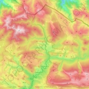
Name: Orbaiceta topographic map, elevation, terrain.
Location: Orbaiceta, Pirineo, 31670, España (42.95044 -1.30187 43.05545 -1.14166)
Average elevation: 3,379 ft
Minimum elevation: 1,339 ft
Maximum elevation: 5,112 ft
La localidad de Orbaiceta está situada en la parte Nordeste de la Comunidad Foral de Navarra y Norte del valle de Aézcoa, a una altitud de 765 m s. n. m. Su término municipal tiene una superficie de 82,31 km² y limita al norte y Este con el monte Aézcoa, común del valle de este nombre, al sur con el municipio de Villanueva de Aézcoa y al oeste con el de Orbara y el monte Aézcoa.
Other topographic maps
Click on a map to view its topography, its elevation and its terrain.