
Ourika topographic map
Interactive map
Click on the map to display elevation.
About this map
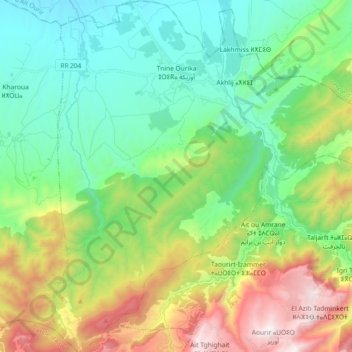
Name: Ourika topographic map, elevation, terrain.
Average elevation: 3,967 ft
Minimum elevation: 2,431 ft
Maximum elevation: 7,372 ft
Other topographic maps
Click on a map to view its topography, its elevation and its terrain.
Oukaimeden
Maroc > Cercle de Tahannaout > Oukaimeden
Oukaimeden, caïdat de Sti Fadma, Cercle de Tahannaout, Province d'Al Haouz, Marrakech-Safi, Maroc
Average elevation: 7,946 ft