
Luncarty topographic map
Interactive map
Click on the map to display elevation.
About this map
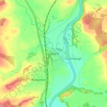
Name: Luncarty topographic map, elevation, terrain.
Location: Luncarty, Perth and Kinross, Écosse, PH1 3YU, Royaume-Uni (56.43292 -3.48724 56.47292 -3.44724)
Average elevation: 121 ft
Minimum elevation: 3 ft
Maximum elevation: 285 ft
Other topographic maps
Click on a map to view its topography, its elevation and its terrain.
Blairgowrie and Rattray
Royaume-Uni > Écosse > Perth and Kinross
Blairgowrie and Rattray, Perth and Kinross, Écosse, PH10 6AB, Royaume-Uni
Average elevation: 397 ft
Moulin
Royaume-Uni > Écosse > Perth and Kinross
Moulin, Perth and Kinross, Écosse, PH16 5EW, Royaume-Uni
Average elevation: 797 ft
Dunning
Royaume-Uni > Écosse > Perth and Kinross
Dunning, Perth and Kinross, Écosse, PH2 0RT, Royaume-Uni
Average elevation: 299 ft
Crieff
Royaume-Uni > Écosse > Perth and Kinross
Crieff, Perth and Kinross, Écosse, PH7 3BS, Royaume-Uni
Average elevation: 377 ft
Scotlandwell
Royaume-Uni > Écosse > Perth and Kinross
Scotlandwell, Perth and Kinross, Écosse, KY13 9NA, Royaume-Uni
Average elevation: 551 ft