
Nigerpass topographic map
Interactive map
Click on the map to display elevation.
About this map
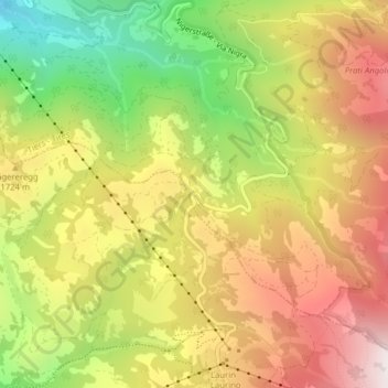
Name: Nigerpass topographic map, elevation, terrain.
Average elevation: 5,420 ft
Minimum elevation: 3,776 ft
Maximum elevation: 6,906 ft
Passhöhe mit Hinweisschild
Other topographic maps
Click on a map to view its topography, its elevation and its terrain.
Rosengartenspitze
Italien > Trentino-Südtirol > Bozen > Tiers
Rosengartenspitze, Tiers, Salten-Schlern, Bozen, Trentino-Südtirol, Italien
Average elevation: 7,336 ft