Geolocate

Clayton topographic map

Click on the map to display elevation.

About this map

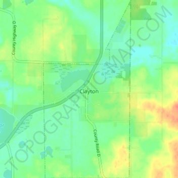
Name: Clayton topographic map, elevation, terrain.

Location: Clayton, Polk County, Wisconsin, United States (45.30987 -92.18744 45.35373 -92.15672)

Average elevation: 1,214 ft

Minimum elevation: 1,161 ft

Maximum elevation: 1,306 ft

Polk County trails, hiking, mountain biking, running and outdoor activities

Other topographic maps

Click on a map to view its topography, its elevation and its terrain.

Cushing

United States > Wisconsin > Polk County

Average elevation: 978 ft

Little Falls

United States > Wisconsin > Polk County

Average elevation: 1,070 ft

Peaslee Lake

United States > Wisconsin > Polk County

Average elevation: 791 ft

Gear up for your next adventure:

📷Action Cameras - Rugged cameras to document your journeys across rugged terrain
🔥Fast-Boil Camping Stoves - Efficient cooking systems for quick trail meals
📶Vehicle Signal Boosters - Improve reception in rural areas while driving to trailheads
📶Satellite Messenger - Communication device off‑grid
🏕️Family Camping Gear - Essentials for group camping trips

As an Amazon Associate, this site earns from qualifying purchases at no extra cost to you.