
Hemington topographic map
Interactive map
Click on the map to display elevation.
About this map
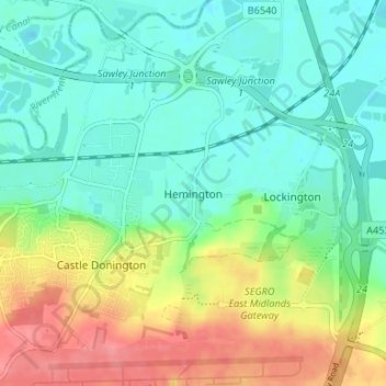
Name: Hemington topographic map, elevation, terrain.
Average elevation: 167 ft
Minimum elevation: 85 ft
Maximum elevation: 322 ft
Other topographic maps
Click on a map to view its topography, its elevation and its terrain.
Ashby-de-la-Zouch
United Kingdom > England > Leicestershire > North West Leicestershire > Ashby-de-la-Zouch
Ashby-de-la-Zouch, North West Leicestershire, Leicestershire, East Midlands, England, United Kingdom
Average elevation: 433 ft
Coalville
United Kingdom > England > Leicestershire > North West Leicestershire
Coalville, North West Leicestershire, Leicestershire, England, LE67 3DW, United Kingdom
Average elevation: 489 ft