
Hagenow topographic map
Interactive map
Click on the map to display elevation.
About this map
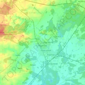
Name: Hagenow topographic map, elevation, terrain.
Average elevation: 108 ft
Minimum elevation: 43 ft
Maximum elevation: 269 ft
Other topographic maps
Click on a map to view its topography, its elevation and its terrain.
Balow
Duitsland > Mecklenburg-Voor-Pommeren > Ludwigslust-Parchim
Balow, Grabow, Ludwigslust-Parchim, Mecklenburg-Voor-Pommeren, Duitsland
Average elevation: 112 ft
Niels
Duitsland > Mecklenburg-Voor-Pommeren > Ludwigslust-Parchim > Bresegard bei Picher
Niels, Bresegard bei Picher, Hagenow-Land, Ludwigslust-Parchim, Mecklenburg-Voor-Pommeren, 19230, Duitsland
Average elevation: 66 ft
Granzin
Duitsland > Mecklenburg-Voor-Pommeren > Ludwigslust-Parchim
Granzin, Eldenburg Lübz, Ludwigslust-Parchim, Mecklenburg-Voor-Pommeren, Duitsland
Average elevation: 213 ft
Blankenberg
Duitsland > Mecklenburg-Voor-Pommeren > Ludwigslust-Parchim
Blankenberg, Sternberger Seenlandschaft, Ludwigslust-Parchim, Mecklenburg-Voor-Pommeren, Duitsland
Average elevation: 95 ft