
Osterburg topographic map
Interactive map
Click on the map to display elevation.
About this map
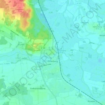
Name: Osterburg topographic map, elevation, terrain.
Average elevation: 95 ft
Minimum elevation: 62 ft
Maximum elevation: 243 ft
Other topographic maps
Click on a map to view its topography, its elevation and its terrain.
Falkenberg
Duitsland > Saksen-Anhalt > Stendal > Altmärkische Wische
Falkenberg, Altmärkische Wische, Seehausen, Stendal, Saksen-Anhalt, Duitsland
Average elevation: 75 ft
Stendal
Duitsland > Saksen-Anhalt > Stendal
Stendal, Saksen-Anhalt, 39576, Duitsland
Average elevation: 135 ft