
Les Epinettes topographic map
Interactive map
Click on the map to display elevation.
About this map
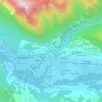
Name: Les Epinettes topographic map, elevation, terrain.
Average elevation: 2,894 ft
Minimum elevation: 1,988 ft
Maximum elevation: 6,473 ft
Other topographic maps
Click on a map to view its topography, its elevation and its terrain.
La Bottière
Frankrijk > Auvergne-Rhône-Alpes > Haute-Savoie > Taninges
La Bottière, Taninges, Bonneville, Haute-Savoie, Auvergne-Rhône-Alpes, Metropolitaans Frankrijk, 74440, Frankrijk
Average elevation: 3,743 ft